Trail Walking Sant Lluís - Cala Rafalet - Photo
© OpenStreetMap contributors
Length
Length
891 m
Max alt
Max alt
38 m
Uphill gradient
Uphill gradient
0 m
Km-Effort
Km-Effort  
961 m
Min alt
Min alt
14 m
Downhill gradient
Downhill gradient
21 m
Boucle
Boucle
No
Creation date :
2022-07-07 10:29:12.0
Updated on :
2022-07-07 12:47:15.215

(0 Reviews)

Walking
Walking
14m
Difficulty : Easy

Scan this QR Code to open this trail in the SityTrail application

FREE GPS app for hiking

Logo SityTrail SityTrail

IGN / Geographical institutes

Download SityTrail from the App Store Download SityTrail from Google Play

Logo SityTrail SityTrail World

The world is yours!

Download SityTrail from the App Store Download SityTrail from Google Play Download SityTrail on Huawei AppGallery

About

Trail Walking of 891 m to be discovered at Balearic Islands, Unknown, Sant Lluís. This trail is proposed by 001548.00b26a1cddd749cd8cbedf38f513cec7.0811.

Elevation profile

Positioning

Country:
Spain
Region :
Balearic Islands
Department/Province :
Unknown
Municipality :
Sant Lluís
Location:
Unknown
Start:(UTM)
610713 ; 4410587 (31S) N.

Trails nearby

Trail Walking Sant Lluís - Rando - Photo
Walking
papounet32

Walking

Very difficult
Sant Lluís, Balearic Islands, Unknown, Spain
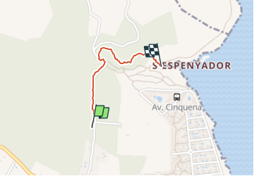
76 km | 91 km-effort
3h 58min
No
Trail Walking Maó - mao - Photo
Walking
guy64600

Walking

Easy
Maó, Balearic Islands, Unknown, Spain
5.4 km | 5.9 km-effort
3h 19min
Yes
Trail Walking Sant Lluís - alcaufar prima Punta A et R - Photo
Walking
bymarc26

Walking

Easy
Sant Lluís, Balearic Islands, Unknown, Spain
6.1 km | 6.8 km-effort
1h 32min
Yes
Trail Walking es Castell - Es Castell 2 - Photo
Walking
Vinceneux

Walking

Medium
es Castell, Balearic Islands, Unknown, Spain
6.6 km | 7.4 km-effort
1h 39min
No
Trail Walking es Castell - es castell sant esteve - Photo
Walking
Vinceneux

Walking

Difficult
es Castell, Balearic Islands, Unknown, Spain
10.8 km | 12.2 km-effort
2h 20min
Yes


Close
My subscriptions